  |
City of Glasgow Calderglen Country Park
|
  |
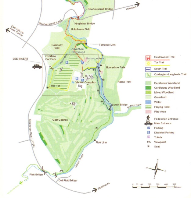 Map
of Calderglen Country Park
( Note: Click here or on above for large format copy ) Formerly part of the Calderglen and Torrance Country Estates, the park extends along a scenic wooded glen forged by the Rotten Calder River, a tributary of the River Clyde. The northern section of the park is a Geological Site of Special Scientific Interest. |
Bridge
over the Horshoe Falls
in the Rotten Calder Water |
Grasslands
and Woodlands
in Calderglen Country Park |
Torrance
Linn ( waterfalls )
in the Rotten Calder Water |
Holmbarns
Field
from Calderglen Country Park |
Kingfisher
Bridge
over the Rotten Calder Water in Calderglen Country Park |
High rise
tenement buildings
in East Kilbride from Calderglen Country Park |
Gatehouse
at the entrance to Calderglen Country Park |
|
Monument
in Calderglen Country Park |
Cafeteria
at Torrance
House
in Calderglen Country Park |
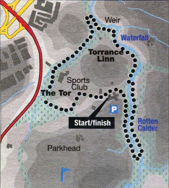 Route Map of Calderglen Country
Park
|
CALDERGLEN COUNTRY PARK - ROUTE DESCRIPTION:
Location: East Kilbride
Map: OS Landranger 64 ( GR 653527 )
Distance: 2 miles ( 3.5km )
Time: 1 hour 10 minutes
Terrain: waymarked paths
Easily reached on foot and by public transport, this walk offers a pleasant wander through the wooded glen of the Calder Water and Rotten Calder on the outskirts of East Kilbride.
Calderglen Country Park consists of four miles of the glen, from the A726 Strathaven Road in the south to the A725 Hamilton Road Expressway in the north,
and is criss-crossed by a network of waymarked and signposted paths.
Added attractions in midwinter are a hot-house conservatory and cafe, and the small zoo and adventure playground may be worth a look for children.
Paths are generally good, although some will be wet and muddy in places. A bit of extra care is needed after cold snaps as East Kilbride’s extra elevation can result
in lingering snow and ice, when the surrounding built-up areas of the Clyde basin are frost-free.
The route begins with the waymarked Tor Trail, which starts from the corner of the car park diagonally across from the zoo and conservatory, beside the country
park exit road. Follow the prepared gravel path through rhododendrons and silver birch to conifers and mixed woodland to footbridge over a burn below the
Tor - a man-made earth mound or fortification of uncertain date.
Cross another footbridge and continue to emerge at the access road and a bridge over the larger Kelvin Burn.
Turn left, cross over the bridge, then right back on to a way marked path.
This section is a bit muddier and narrower than before, but leads round through woodland beside the burn with views north over fields to the houses and high flats of East Kilbride.
Cross a bridge back over a burn and descend steps to join the red way-marked route coming in from the right.
Turn right, descend steps, cross another footbridge over the Kelvin Burn and continue to where the yellow and red routes divide.
Turn down left to Torrance Linn on the Rotten Calder and follow the path near the river, round below the adventure playground.
This small waterfall is one of many in the glen.
Ascend slightly to a junction and turn left down to the bridge over the Rotten Calder at Horseshoe Falls.
Cross over and follow the east bank of the river to steps leading down to the new South Bridge.
Cross, ascend to the west bank and follow the path rightwards through woodland back to the visitor centre and courtyard cafe.
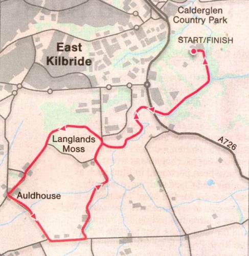 |
Route Description for Langlands Moss at Calderglen Country Park

Glencoe | Ben Nevis | Knoydart | Isle of Skye | Isle of Arran | The West Highland Way
The Eastern Highlands | The Central Highlands | The Southern Highlands | The NW Highlands