West Highland Way: Trailblazer Ochils and Campsie Fells

 Bearsden & District

Drymen

West Highland Way - Map West Highland Way: Footprint Map


Photographs of a circular walk starting and finishing at the village of Drymen

 with views of:-

Campsie Fells, Kilpatrick Hills, Loch Lomond,

Conic Hill, Luss Hills and Duncryne 
Clachan Inn in the village square of Drymen

Clachan Inn ( dating from 1734 ) in the village square of Drymen

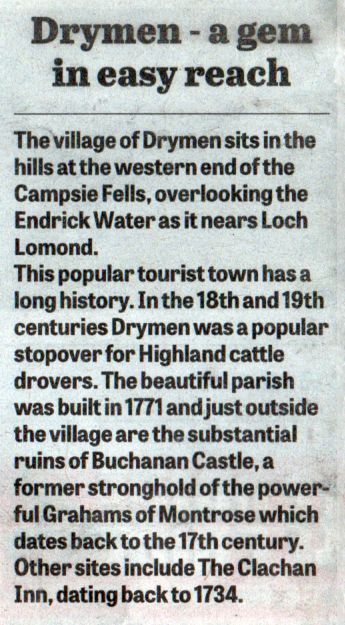
Drymen is at the western end of the 
Campsie Fells and to the South of Loch Lomond.

In the 18th and 19th centuries Drymen was a stopover point for Highland cattle drovers.

Drymen is only a short distance off the route of the 
West Highland Way

and within the bounds of the Loch Lomond and Trossachs National Park


Drymen info

Drymen


The Campsie Fells from Gallowhill Forest on the outskirts of Drymen

The Campsie Fells from Gallowhill Wood

 on the outskirts of Drymen


The Kilpatrick Hills from the outskirts of Drymen

The Kilpatrick Hills

from the outskirts of Drymen


Loch Lomond from the outskirts of Drymen

Loch Lomond

from 
the outskirts of Drymen.


Conic Hill on the West Highland Way from the outskirts of Drymen

Conic Hill on the West Highland Way

from 
the outskirts of Drymen.


Luss Hills from the outskirts of Drymen

Luss Hills

from 
the outskirts of Drymen


Coldrach Farm on the outskirts of Drymen

Coldrach Farm

on the outskirts of Drymen


The Old Buchanan Smithy on the road from Drymen to Balmaha

The Old Buchanan Smithy

on the road from Drymen to Balmaha

This was built by the Duke of Montrose in the early 19th century.

 It initially housed workers on his estate.

It also housed the estate's blacksmith's shop,

 hence the name of the hamlet.


Duncryne ( "The Dumpling " ) from the viewpoint above Drymen

Duncryne ( "The Dumpling " )

from the viewpoint above Drymen


The Parish Church at Drymen

The Parish Church ( built 1771 ) at Drymen


The Buchanan Arms Hotel at Drymen

The Buchanan Arms Hotel at Drymen

The origins go back to the Buchanan of Drumakill,

Lairds who owned extensive lands mainly at Drymen, Ross Priory and Gartocharn.

Built in 1763 it was an Inn and Farmhouse with the
adjoining Farm of Ballanton.

About 1860 it was purchased by James 4th Duke of Montrose

and leased to a Mr Robe Buchanan followed shortly after by Mr James Buchanan.

In 1935 the hotel was sold by Mr David Burnett to a Mr Grant.

The Hotel and Buchanan Arms Farm were next owned by Mr Charles Guy

 - his brothers, Albert and Arthur, thereafter took over control at Buchanan Arms Hotel.

The Guys sold to Scottish Highland Hotels and,

since 2013, the hotel has been under the ownership of Nordfield Properties Ltd.


The village shop in Drymen

The village shop in Drymen


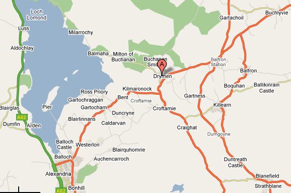
Map of Drymen Area

Map of Drymen Area


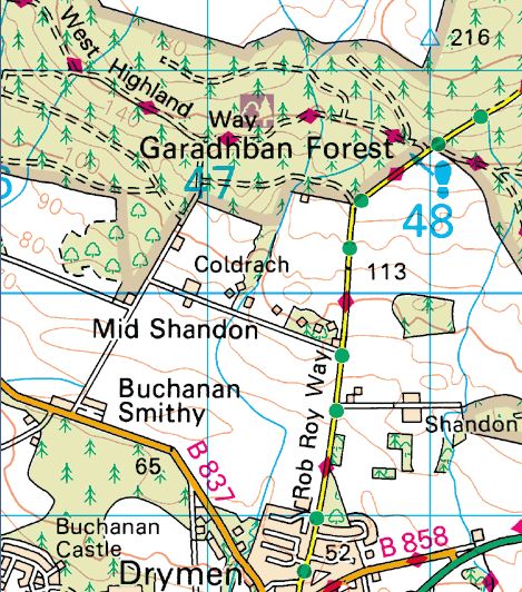
Map of Drymen Walk area

Map of the Drymen Walk Area


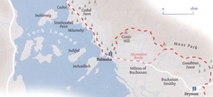
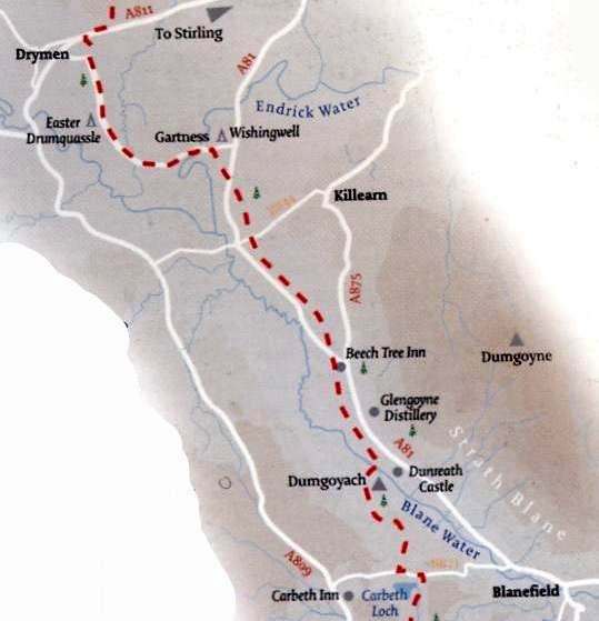
Route Map of West Highland Way from Carbeth to Drymen

Route Map of West Highland Way

from Drymen to Balmaha


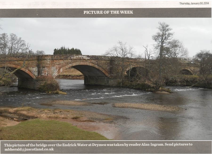
Drymen Bridge over the Endrick Water


Route Map of West Highland Way from Carbeth to Drymen

Route Map of West Highland Way

from Carbeth to Drymen


DRYMEN CIRCULAR WALK - ROUTE DESCRIPTION:


This is a short circular walk round the northwest of Drymen of about two miles and one hour duration.
It is a picturesque part of the country with views overlooking Loch Lomond and has many interesting extensions to the walk.
The walk starts at the Stirling Road Car Park in
Drymen where ample car parking is available.
lt turns left on leaving the carpark and then right at the Square into Gartmore Road.
It leaves the village on passing the Clachan Inn and Balmaha Road on the left and after an attractive row of houses continues on a narrow country road beside the relocated Primary School — a lovely environment for the local children.
The road is not very busy but watch out for traffic in both directions as it climbs gradually passing fields of cattle on either side and the entrance to a prosperous looking farm on the right. In early winter these fields are known to be an attraction as a feeding ground for large colonies of Canada geese.
At the next junction on the left, the walk leaves Gartmore Road ( continuing on can join up with the Garadhban Forest path which is part of the West Highland Way ) and passes through stone pillars to Coldrach Lodge with its beautiful garden. This is a lovely single track road and leads to a few large individually built houses with well established gardens which have wonderful views overlooking the Kilpatrick Hills,
Loch Lomond and the Luss Hills. Among the row of houses, look out for the one with the thatched roof.
After the houses, the walk continues on a farm track and passes by the refurbished Coldrach Farm which was empty for many years and also the outhouses which are being renuvated to be used as lodges.
It turns left at the junction and continues along the farm track with fields of cattle and sheep on either side and to the right views of the impressive Conic Hill and
Loch Lomond.
A narrow path straight ahead at the t-junction provides an extension to the walk as it eventually joins up with the
West Highland Way.
The walk changes back to a metal road surface on reaching the houses at Buchanan Smithy. It is a very small hamlet which served the Buchanan Estate and as a point of interest pause in front of the busy
Balmaha Road to look right at the old blacksmith’s forge in the centre of the estate cottages.
The walk then turns left to follow the road back into
Drymen and on looking back the ideal location can be seen at the top of the field of the Coldrach Farm and attractive houses.
On entering the village, the walk can take either the old Balmaha Road on the left with its cottage style houses back to the Clachan Inn and the Square or pass by the side entrance of the Winnock Hotel and go under the arch to the Square and a short walk back to the carpark.


 Drymen Gallery Photo Gallery  :: Campsie Fells Photo Gallery :: West Highland Way Photo Gallery

<< Back : Bearsden Walks Index :: Next >>


Scotland Index :: Scottish Peaks :: Scotland Walks

Glencoe | Ben Nevis | Knoydart | Isle of Skye | Isle of Arran

The Eastern Highlands | The Central Highlands | The Southern Highlands | The NW Highlands


Adventure Travel : Worldwide Mountaineering : Site Index

fb icon  google+ icon Linkedin icon  twitter


Guide Books & Maps - Scotland:-


West Highland Way: Footprint MapWest Highland Way - Map West Highland Way - Map Western Scotland & the Western Isles OS Road Map Northern Scotland OS Road MapSouthern Scotland OS Road MapGlasgow Popular Hills - Map

Loch Lomond North - Tyndrum, Crianlarich, Arrochar - OS Explorer Map Loch Lomond and Inverary OS Landranger Map  Loch Lomond South OS Explorer Map  Loch Lomond North OS Explorer Map


The High Mountains of Britain & Ireland  Munros Tables SMC  The Munros - Scotland's Highest Mountains  Scotland - Lonely Planet  NW Highlands - SMC Guide  Exploring the Far NW of Scotland  Guide to Walks in NW Highlands

Walking in Scotland - Lonely Planet Mountain: Exploring Britain's High Places  National 3 Peaks Walk Scottish Highlands Hillwalking Guide The Scottish Islands Bouldering in Scotland

Glasgow Visitor Guide - Colin Baxter Itchy Insider's Guide to Glasgow Glasgow Footprint Pocket Guide Glasgow Insight Pocket Guide Glasgow Guide Pub Companion Glasgow Scotland's Highlands & Islands - Rough Guide Scotland - Rough Guide

Glasgow Insight Pocket GuideCollins Street Map of GlasgowGlasgow: Then & NowThey belonged to Glasgow Phillips Street Atlas of Glasgow & West Central Scotland Glasgow: The Photographic Atlas100 Hillwalks around Glasgow 50 Walks in Glasgow & SW Scotland

Visit Scotland - Touring Guide Scotland: Where to Stay - Hotels & Guest Houses Scotland: Where to Stay - Bed & Breakfast Rough Guide ScotlandScottish Highlands & Islands - Rough Guide Scotland - Lonely PlanetScotland's Highlands & Islands - Lonley Planet Great Glasgow StoriesGlasgow & Surroundings - Insight Guide

West Highland Way: Official GuideWest Highland Way: Rucksac ReadersWest Highland Way: TrailblazerThe West Highland WayWest Highland Way: Footprint MapWest Highland Way - Map West Highland Way - Map West Highland Way Wet Highland Way - Official Guide

Munro Almanac The High Mountains of Britain and Ireland The Munros: Scottish Mountaineering Club The Isle of Skye The Isle of Arran Wilderness Walks Ski Mountaineering in Scotland

More Wilderness Walks 50 Best Routes on Skye and Raasay Skye - W.A.PoucherMagic of the Munros Mountaineering in Scotland and Undiscovered Scotland by W.H.MurrayA Long Walk on the Isle of Skye

Classic Climbs - Central & Southern Highlands The Isle of Arran Lonely Planet, Walking in ScotlandPathfinder Guide: Skye and NW Highlands WalksPathfinder Guide: Fort William and Glen Coe Walks Rambler's Guide: Ben Nevis and Glen Coe50 Best Routes on Skye and Raasay - Chris Townsend


Google Analytics


Google Analytics 

extremetracking
 eXTReMe Tracker


extremetracking
Sitelock caingram.com
SiteLock
Sitelock
Sitelock caingram.info
SiteLock
Sitelock